Residential Map of Hankou town, Hubei
Item
-
Title
-
Residential Map of Hankou town, Hubei
-
Description
-
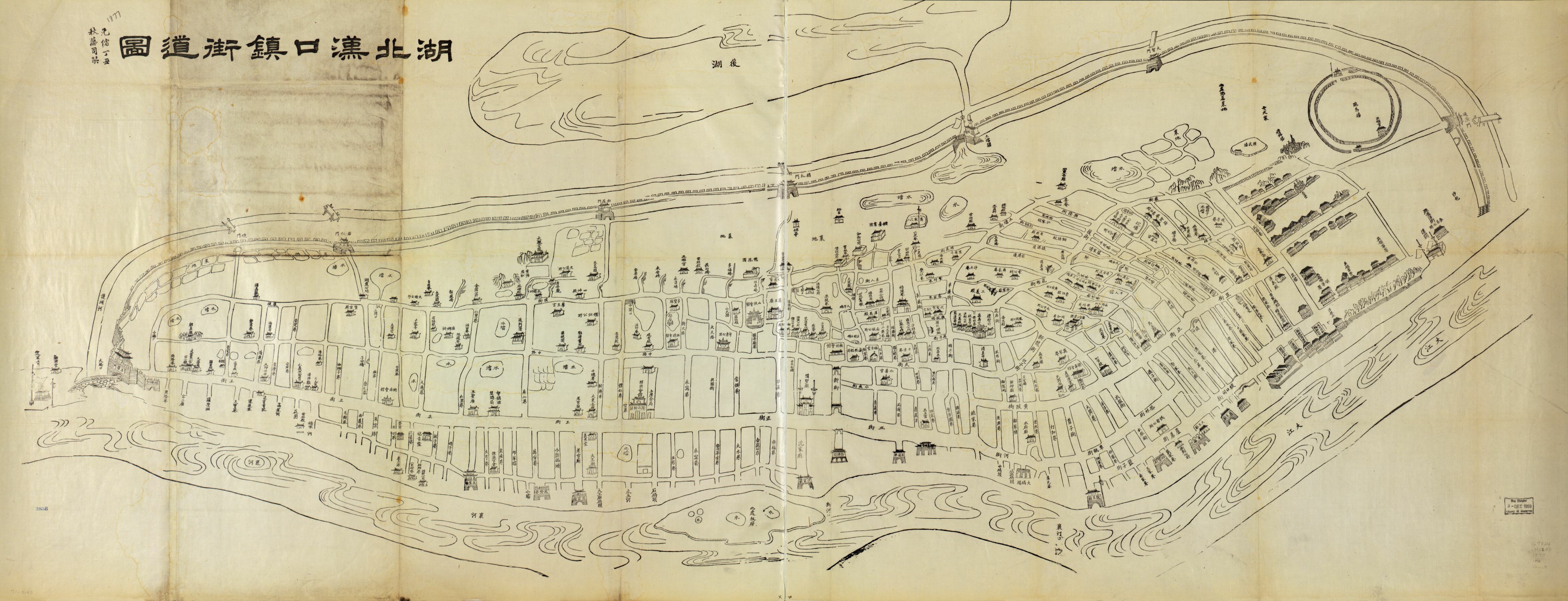
This map, titled Hubei Hankou zhen jiedao tu (湖北汉口镇街道圖), is attributed to Fang Sikan and is dated 1877 (Text in the upper left corner beside the title). The map is woodblock print on a 63 x 165cm sheet, with a scale of 1:5,000 and is oriented with the north in the upper right corner (Library of Congress).
The map centers its focus on Hankou almost exclusively, depicting the city within the bounds of the wall, the large Houhu lake to the northwest (後湖), and the meeting rivers (the Hanshui and Yangtze) to the south. Interestingly, the river dubbed Hanshui (漢水) in other maps is here called xianghe (襄河). Furthermore, the way the map is presented frames the river, forming Hankou’s natural southern border, as continuous, while in reality (and in following with the map’s labeling) it meets the Yangtze just after the island (labeled only as “lumber yard here” [此處板廠 ?]). The lake to the North, Houhu, is also oddly placed, with the Houhu in modern maps appearing far further north, with another river cutting between it and Hankou
The wall is depicted very prominently, with its corresponding gates all being labeled and drawn in detail. A number of buildings have been selected for more specific portrayal as well, particularly those along Main Street (zhengjie, 正街?). While this map lacks a formal distinction between the Chinese city and the English Concession, they are made clearly distinguishable by the artist’s attention to architectural style. The European style buildings along Hualou road are joined with a church and horse race track, along with labeled English businesses and the consulate in the far bottom right.
By constructing Hankou as a continuous whole, contained within the exterior wall and located in relation to natural markers like the river and Houhu lake, Fang Sikan (and other potential contributors) assert the unity of the city despite the creation of the English concession in 1862. The map maker’s attention to street names, landmark buildings, and potentially interesting sites like the race track and the Lou Meeting Hall (絡與會館), convey accessibility and potentially frame the city as inviting for tourists and merchants.
-
Creator
-
Fang Zikan
-
Source
-
Hubei Sheng . Guan Shu Ju. Hubei Hankou zhen jie dao tu. [Hubei: Fang si kan, Qing Guangxu 3 nian, 1877] Map. https://www.loc.gov/item/gm71005145/.
-
Date
-
1877
-
Contributor
-
Hubei Provincial Government