-
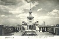 The Sino-Soviet Friendship Building
 A postcard depicting the Sino-Soviet Friendship Building. The building was later renamed the Shanghai Exhibition Centre following the deteriorating relationship between the USSR and the PRC.
-
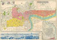 The New Map of Shanghai
 A map made after the Imperial Japanese army occupied Shanghai. The inset displays a part of the Zhabei district, an area which saw a great deal of military action and so was of interest to the Japanese as a potential sight for new development.
-
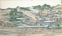 The Taiping Rebellion
 The illustration depicts a battle of the Taiping rebellion, with numerous casualties visible in the foreground, and a countryside town laid to waste in the background. An encroaching army can be seen in the bottom left corner of the artwork.
This artwork was originally produced by Wu Youru in 1886. The digital rendition of this artwork was originally 1,024 × 595 pixels.
-
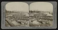 Shanghai Bund 1908
 An image depicting numerous boats docked on the Shanghai Bund, with western styled buildings in the background of the image.
The picture was originally taken in stereographic format in 1908 by the United Photographic Company. The photo was printed on card stock in a 9 x 18cm format.
-
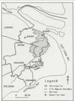 Satellite Towns in Shanghai City Region 1987
 A map of all the seven successful satellite towns in the Shanghai City region as of 1987.
-
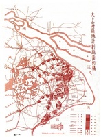 First Draft of Shanghai Master Plan
 The first draft of a post-WW2 plan for Shanghai.
-
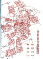 Third Draft of Shanghai Master Plan
 A post-WW2 design for Shanghai that emphasized broad regional planning.
-
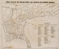 Street plan of the English, French and American settlements
 This map depicts the street plan of the English, French, and American settlements in Shanghai as of 1870. The map was created by the English mapmaking company Stanford's Geographical Establishment in order to be published in the English-language Shanghai newspaper North China Daily News. The map has a 1 : 10,200 scale and is oriented more or less North to South, though it is rotated slightly clockwise. While the map lacks a conventional legend, it does have a list of every major street in each of the foreign settlements off to the side. These streets are also labelled on the map, which also notes some significant locations or landmarks.
The North China Daily News was the most influential foreign newspaper in China from the mid 19th to early 20th centuries. Its audience would primarily have been the Shanghai's English-speaking population of English and Americans. The map reflects this, as it transliterates the Chinese names of streets into the English alphabet. Somewhat interestingly, the map leaves the names of streets in the French settlement unchanged, using French words like "rue" (street). While the map depicts the foreign settlements in great detail, it leaves a large blank space where the old walled city of Shanghai would be. This might indicate that that area was thought of as irrelevant to the readers of the North China Daily News, implying that foreigners rarely visited the Chinese part of the city. Furthermore, that the map depicts all of the foreign settlements implies that foreigners moved between settlements instead of simply remaining in those of their respective nations. People only need detailed street maps of places they intend to visit.
-
 Shanghai 1884
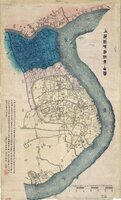
 Originally drawn by Yucang Xu in 1875, later edited and published by Dian She Zhai in 1884, this map depicts the urban layout of Shanghai in 1884. The map includes both the county and foreign concessions with distinctions as follows: Chinese area in yellow, French in red, British in blue, and American in orange. The map contains Chinese text, describing various locations in the city.
The Huangpu river takes up the right portion of the map, and using it as a geographical marker sans included compass allows us to assume the top portion of the map corresponds to north, and the bottom portion the south. The map is scaled 1:5400 and was originally drawn on paper, measuring 110 x 66 cm.
-
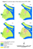 Land use maps of the Shanghai area
 Between 1979 and 2008 urban land in the Shanghai area increased by 210.18%.
-
 Plan to rechannel the Huangpu River
 In his book The International Development of China, Sun Yat-sen outlined a plan to reroute the Huangpu River in order to create a "New Bund" for Shanghai.