Japanese Occupation 1937-1945
The Japanese occupation of Shanghai put an end to efforts to implement the Greater Shanghai Plan. However, Shanghai's new Japanese rulers had plans of their own for the city, many of which were quite extravagant. These plans acted as a form of propaganda, asserting that Shanghai's future was in the hands of the Japanese Empire. Ironically, the most realistic urban plan put forward by the occupying government was the "Greater Shanghai Metropolitan Plan," which was heavily based on the Greater Shanghai Plan!
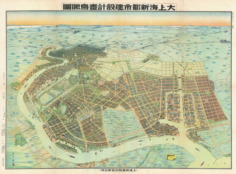
Greater Shanghai Metropolitan Plan
This rendition of Japan's Greater Shanghai Metropolitan Plan is extremely detailed, so we encourage viewers to click the image to go to the item page and see the image at its full resolution. This might cause some lag, but be patient, it is truly incredible once it loads!
The Greater Shanghai Metropolitan Plan reused many of the ideas included in the Greater Shanghai Plan. Much like its predecessor, the Metropolitan Plan was highly focused on diminishing the relative importance of the International Settlement and French Concession. To this end, both plans centered on the creation of a new urban center for Shanghai to the North of the International Settlement. This is highly visible in the above depiction of the Metropolitan Plan: The proposed urban center dominates the foreground while the old Chinese city and the International Settlement are consigned to the background. Other similarities between the two plans that are visible in the above image include the planned implementation of rectilinear (grid-patterned) streets, as well as a similar civic center. During the war the International Settlement was officially dissolved and returned to China, though China only actually regained control after the Second World War ended. The dissolution of the foreign concessions rendered the primary purpose of both plans somewhat moot.
The above map was created by Fusazō Sugie, a Japanese printmaker living in Shanghai at the time of Japanese occupation. The lower right of the map contains an inset image of the Zhabei district, a part of Shanghai that had seen particularly intense fighting, and was consequently a target for future Japanese development. The reconstruction of the war-ravaged Zhabei district was also of interest to the Kuomintang Government and later to the Chinese Communist Party.