Economic Reform Reaches Shanghai: Pudong New Area 1990-2000s
The mid-1980s saw a profound reversal of fortune for Shanghai. In 1985 the central government finally approved increased expenditures in Shanghai and in 1988 it capped Shanghai's tax contributions, freeing up a great deal of revenue for regional use. Perhaps the largest boon arrived in 1984 when the central government named Shanghai among 14 new cities that would be made open to foreign development. The CCP's attitude towards Shanghai had undergone a fundamental transformation: Rather than toiling thanklessly to provide revenue for the rest of China, Shanghai was to be reborn as a world-class city whose shining example would lead the rest of China to prosperity. This new stance is best encapsulated in Deng Xiaoping's 1992 designation of Shanghai as "the head of the dragon."
Finally obtaining the funding and approval it had long needed, new urban plans were quickly drawn up for the Shanghai area. 1986, a new Master Plan was outlined for Shanghai, calling for the city to return to international prominence by 2020 (a goal that it more than surpassed). Notably, this plan included the construction of even more satellite towns. By 1987, there were seven functional satellite towns around Shanghai (viewers can refer to the map on our "Topic: Satellite Cities" page). Shanghai was also regionalized, giving the city a larger tax base and allowing the municipal government more autonomy in directing the city's development than previous administrations had enjoyed- even those before Communist rule.
In 1986 the municipal government of Shanghai also established the Consultative Small Group for the Development of Pudong. A clear attempt at continuity with previous urban plans can be seen in Zhao Zukang's inclusion as a prominent member of that Group. Other periods of urban planning rhetoric were also drawn upon; the portrayal of Shanghai as a "key-point city" was a revival of the Soviet-influenced belief in the usefulness of large cities and their economies of scale. The 1990s can therefore be viewed as a period in which China reconciled many of the seemingly disparate urban planning policies that it had pursued over the 20th century.
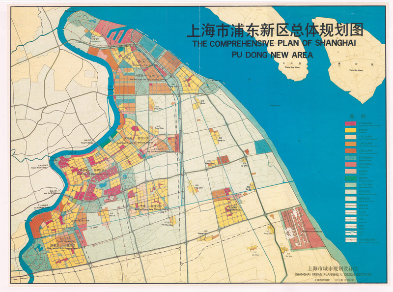
In April of 1990, Li Peng, the Premier of the People's Republic of China, officially approved the beginning of the Pudong New Area project. This plan named Pudong as a new special economic zone that was open to foreign investment and was heavily influenced by the goals of the 1946 Shanghai Master Plan. Cross-river connections over the Huangpu were once again called for, and were at last actually built. The Nanpu and Yangpu bridges, completed in 1991 and 1993, respectively, are among the main arteries through which traffic passes between Pudong and Puxi. The Comprehensive Plan of Shanghai Pudong New Area, pictured below, depicts the proposed locations of these bridges on the West edge of Pudong. Also visible is the Yanan road tunnel, connecting directly with the Lujiazui financial district near the middle of the image. The complex zoning of Pudong can be seen in the array of colors marking the map, with each color designating a different type of land use. Lujiazui, marked in red as a space for commercial and public facilities, saw the construction of many skyscrapers over the 1990s, including the Oriental Pearl Tower, which was completed in 1995. Lujiazui's skyline, and Pudong as a whole, have become emblematic of China's modernization.
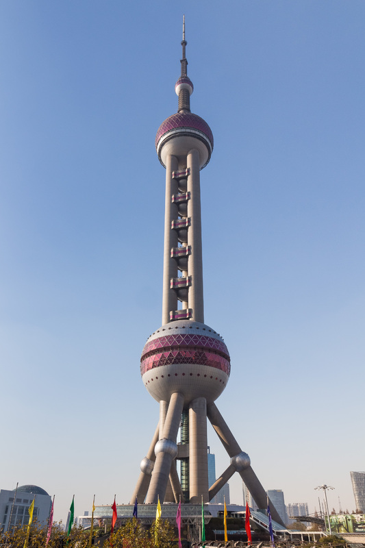
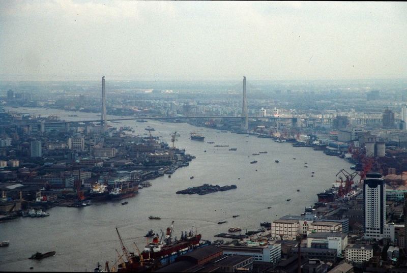
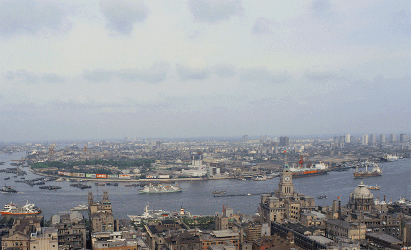
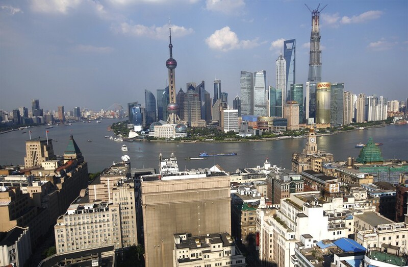
The two images below, taken in almost exactly the same location less than thirty years apart, highlight the dramatic and rapid transformation of Pudong's skyline between the 1990s and 2000s. The Oriental Pearl Tower, mentioned above, is visible in the later photo on the other side of the Huangpu.
In 2006, the 1-9-6-6 plan arranged Shanghai's entire territory into a ranked system. The plan cast Shanghai as a central city surrounded by nine new satellite cities, sixty new market towns, and six hundred villages. The 1-9-6-6 plan was noteworthy because it synthesized a variety of existing planning policies into a single system, the goal of which was to facilitate a greater integration of urban and rural areas. Urban planning in Shanghai would no longer be confined to the central metropolis or a select few satellites. Instead, nearly every square foot of Shanghai's administrative territory would be given a role to play. To see the specific locations of new satellite towns proposed under this plan, viewers should refer to the right map on our "Topic: Satellite Cities" page.