-
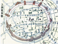 Qing Dynasty Shanghai
 Depicted in this image is Shanghai in its original circular-walled layout. At this point in the cities history, perforations had been made through the defensive wall, in order for trading routes to be established. Waterways can be seen outlined in blue, and the central City God Temple can be seen represented by a group of houses in the middle.
This map is a colored reproduction of an early 19th century map, and has been rendered in a digital format.
-
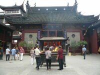 City God Temple
 Pictured here is the City God Temple of Shanghai. As one of the oldest surviving buildings in the city, it's held various historical roles and was once where the Merchant Guilds had their meetings.
This image was originally taken as a digital photograph in 2007.
-
 Nanjing Road Today
 The image above depicts Nanjing Road today. The road is highlighted in purple and runs horizontally across the map. The red dots on either side of the road show shops and businesses that line the street.
This image was created digitally, and is presented in its original format
-
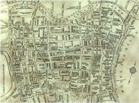 Nanjing Road Pre-1943
 Pictured above is a map of Shanghai, showing the location of Nanjing Road, formerly named Nanking Road. The name change occurred in 1943, so even without a precise time associated with the resource we can assume that it was created before then. Nanjing Road can be found near the middle of the map, running horizontally.
The original map was penned on paper, and then digitized for modern use.
-
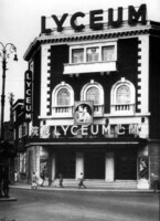 Lyceum Theater
 Pictured here is the Lyceum Theatre, originally built in 1931. It was utilized by British acting societies and later as a theater. The Lyceum Theatre was one of the many entertainment venues built in Shanghai in the 1920s and 30s.
This image was originally a black and white photograph, printed on paper. Its estimated date of capture was 1931-39.
-
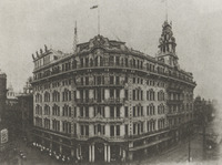 Wing On Department Store
 This image shows the towering Wing On department store on Nanjing Road in the 1920s. This store embodied the consumer culture of its time, and was part of the larger Nanjing Road shopping experience.
This source was originally a photograph, taken in 1920.
-
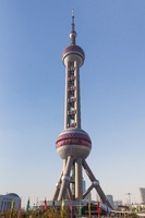 The Oriental Pearl Tower
 The Oriental Pearl Radio &Television Tower is a skyscraper in Pudong's Lujiazui district.
-
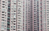 Soviet Style Apartments
 Soviet style apartments in Shenzhen, China.
-
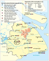 New Satellite Towns Planned Between 1999 and 2017
 A map of the Shanghai region which labels all of the satellite towns planned between 1999 and 2017.
-
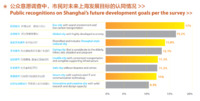 Shanghai Future Development Goals
 The Shanghai Master Plan 2017-2035 asserts that its goals are supported by the public.
-
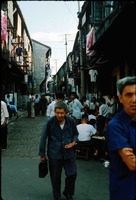 Street Scene 1982
 A street scene depicting a moment of life in a Lilong alleyway community. Until the 2000s, the majority of Shanghai's population resided in Lilong houses.
-
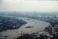 View of the Yangpu Bridge and Pudong from the Oriental Pearl Tower
 A photograph of the Yangpu Bridge, which spans the Huangpu river to connect Pudong to the rest of the city.
-
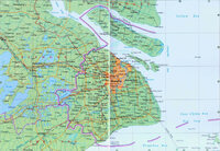 Shanghai Municipality Map 2010
 A detailed map of the Shanghai Municipality as of 2010.
-
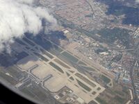 Shanghai Hongqiao International Airport
 An aerial view of Shanghai's Hongqiao International Airport. The large terminal in the lower left of the image was constructed in preparation for Expo 2010.
-
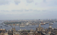 Pudong Skyline in 1987
 An image of the Lujiazui district in Pudong in 1987 as scene from the Bund.
-
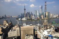 Pudong Skyline in 2013
 An image showing the remarkable skyline of Pudong's Lujiazui financial district in 2013.
-
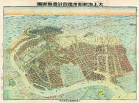 Greater Shanghai Metropolitan Plan
 A Japanese plan for Shanghai that was heavily inspired by the Greater Shanghai Plan.
-
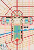 Proposed Greater Shanghai Plan Government Complex
 A modern, digital depiction of what the proposed government complex as outlined by the Shanghai Greater Plan might have looked like. A key is provided in the bottom left hand corner.
This source was created in 2014 by Wikipedia contributor Philg88. It was originally created in Adobe Illustrator.
-
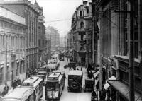 Shanghai 1920s
 Shown here is Jiujang Road in Shanghai circa the 1920s. The streets are bustling with trams, cars, and pedestrians. Long rows of shops line both sides of the streets, with customers rushing in and out of them.
-
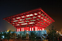 The Chinese Pavilion at Expo 2010
 An exterior view of the Chinese national pavilion at Shanghai Expo 2010.
-
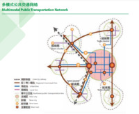 Multimodal Transport Network
 A plan for Shanghai's new multimodal transport network. It extends from the city center into urban clusters in the surrounding area. The network is intended to reduce the population in Shanghai by making it possible to commute to jobs from outside the city.
-
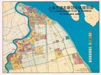 The Comprehensive Plan of Shanghai Pudong New Area
 A plan of the Pudong New Area. It details the intended uses of various portions of Pudong. As of 1991, the plan had not yet been enacted in its entirety.
-
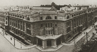 Shanghai Municipal Council Building
 Pictured in this image is the Shanghai Municipal Council building in 1921. The building is of western construction with a flat roof and European style façade.
-
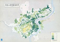 Average Residential Space Per Person in Shanghai Urban Area
 A map showing the amount of space per person in Shanghai. It was published in 1984 but used data from 1979. It reveals how crowded Shanghai was following years of neglect and decay.
Key:
Yellow- Fairly large
Light Green- Regular
Green- Rather crowded
Dark Green- Crowded
-
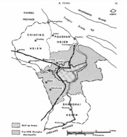 Proposed Satellite Towns in the Shanghai Region, 1958
 A map that outlines the potential locations of satellite towns in the Shanghai region as of 1958. This plan was only ever partially implemented.
 Qing Dynasty Shanghai Depicted in this image is Shanghai in its original circular-walled layout. At this point in the cities history, perforations had been made through the defensive wall, in order for trading routes to be established. Waterways can be seen outlined in blue, and the central City God Temple can be seen represented by a group of houses in the middle. This map is a colored reproduction of an early 19th century map, and has been rendered in a digital format.
 City God Temple Pictured here is the City God Temple of Shanghai. As one of the oldest surviving buildings in the city, it's held various historical roles and was once where the Merchant Guilds had their meetings. This image was originally taken as a digital photograph in 2007.
 Nanjing Road Today The image above depicts Nanjing Road today. The road is highlighted in purple and runs horizontally across the map. The red dots on either side of the road show shops and businesses that line the street. This image was created digitally, and is presented in its original format
 Nanjing Road Pre-1943 Pictured above is a map of Shanghai, showing the location of Nanjing Road, formerly named Nanking Road. The name change occurred in 1943, so even without a precise time associated with the resource we can assume that it was created before then. Nanjing Road can be found near the middle of the map, running horizontally. The original map was penned on paper, and then digitized for modern use.
 Lyceum Theater Pictured here is the Lyceum Theatre, originally built in 1931. It was utilized by British acting societies and later as a theater. The Lyceum Theatre was one of the many entertainment venues built in Shanghai in the 1920s and 30s. This image was originally a black and white photograph, printed on paper. Its estimated date of capture was 1931-39.
 Wing On Department Store This image shows the towering Wing On department store on Nanjing Road in the 1920s. This store embodied the consumer culture of its time, and was part of the larger Nanjing Road shopping experience. This source was originally a photograph, taken in 1920.
 The Oriental Pearl Tower The Oriental Pearl Radio &Television Tower is a skyscraper in Pudong's Lujiazui district.
 Soviet Style Apartments Soviet style apartments in Shenzhen, China.
 New Satellite Towns Planned Between 1999 and 2017 A map of the Shanghai region which labels all of the satellite towns planned between 1999 and 2017.
 Shanghai Future Development Goals The Shanghai Master Plan 2017-2035 asserts that its goals are supported by the public.
 Street Scene 1982 A street scene depicting a moment of life in a Lilong alleyway community. Until the 2000s, the majority of Shanghai's population resided in Lilong houses.
 View of the Yangpu Bridge and Pudong from the Oriental Pearl Tower A photograph of the Yangpu Bridge, which spans the Huangpu river to connect Pudong to the rest of the city.
 Shanghai Municipality Map 2010 A detailed map of the Shanghai Municipality as of 2010.
 Shanghai Hongqiao International Airport An aerial view of Shanghai's Hongqiao International Airport. The large terminal in the lower left of the image was constructed in preparation for Expo 2010.
 Pudong Skyline in 1987 An image of the Lujiazui district in Pudong in 1987 as scene from the Bund.
 Pudong Skyline in 2013 An image showing the remarkable skyline of Pudong's Lujiazui financial district in 2013.
 Greater Shanghai Metropolitan Plan A Japanese plan for Shanghai that was heavily inspired by the Greater Shanghai Plan.
 Proposed Greater Shanghai Plan Government Complex A modern, digital depiction of what the proposed government complex as outlined by the Shanghai Greater Plan might have looked like. A key is provided in the bottom left hand corner. This source was created in 2014 by Wikipedia contributor Philg88. It was originally created in Adobe Illustrator.
 Shanghai 1920s Shown here is Jiujang Road in Shanghai circa the 1920s. The streets are bustling with trams, cars, and pedestrians. Long rows of shops line both sides of the streets, with customers rushing in and out of them.
 The Chinese Pavilion at Expo 2010 An exterior view of the Chinese national pavilion at Shanghai Expo 2010.
 Multimodal Transport Network A plan for Shanghai's new multimodal transport network. It extends from the city center into urban clusters in the surrounding area. The network is intended to reduce the population in Shanghai by making it possible to commute to jobs from outside the city.
 The Comprehensive Plan of Shanghai Pudong New Area A plan of the Pudong New Area. It details the intended uses of various portions of Pudong. As of 1991, the plan had not yet been enacted in its entirety.
 Shanghai Municipal Council Building Pictured in this image is the Shanghai Municipal Council building in 1921. The building is of western construction with a flat roof and European style façade.
 Average Residential Space Per Person in Shanghai Urban Area A map showing the amount of space per person in Shanghai. It was published in 1984 but used data from 1979. It reveals how crowded Shanghai was following years of neglect and decay. Key: Yellow- Fairly large Light Green- Regular Green- Rather crowded Dark Green- Crowded
 Proposed Satellite Towns in the Shanghai Region, 1958 A map that outlines the potential locations of satellite towns in the Shanghai region as of 1958. This plan was only ever partially implemented.